Modern agriculture is no longer limited by effort — it is limited by information latency.
By the time visual symptoms appear in a crop, the underlying stress — chlorophyll degradation, moisture imbalance, canopy disruption, or soil variability — has already impacted yield potential.
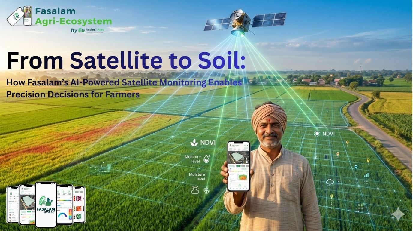
At Rashail Agro, we address this gap through AI-powered satellite monitoring, delivered weekly via the Fasalam Super App and WhatsApp, combined with post-report human advisory support.
This system transforms remote sensing data into field-level, actionable agronomic intelligence.
Why Satellite Monitoring Is Becoming Essential in Agriculture
Traditional crop monitoring relies on:
- Manual field scouting
- Experience-based assumptions
- Uniform input application
However, satellite data reveals what the human eye cannot:
- Sub-canopy stress before visible symptoms
- Intra-field variability across zones
- Moisture stress trends over time
- Nutrient uptake efficiency, not just application
📌 Precision farming begins when decisions are data-validated, spatially resolved, and time-sensitive.
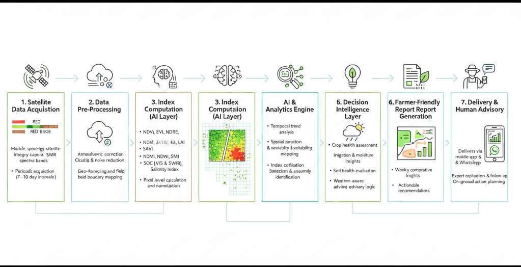
Fasalam’s Weekly Satellite Monitoring: Technical Overview
Each Fasalam satellite report is generated using multi-spectral satellite imagery, processed through AI/ML-based analytical models, and validated through agronomic logic.
🔭 Data Source & Processing
- Multi-band satellite imagery (Visible, Red Edge, NIR, SWIR)
- Periodic image capture (7–10 day interval depending on cloud cover)
- Noise reduction & atmospheric correction
- Pixel-level index computation
- Zone-based aggregation for field insights
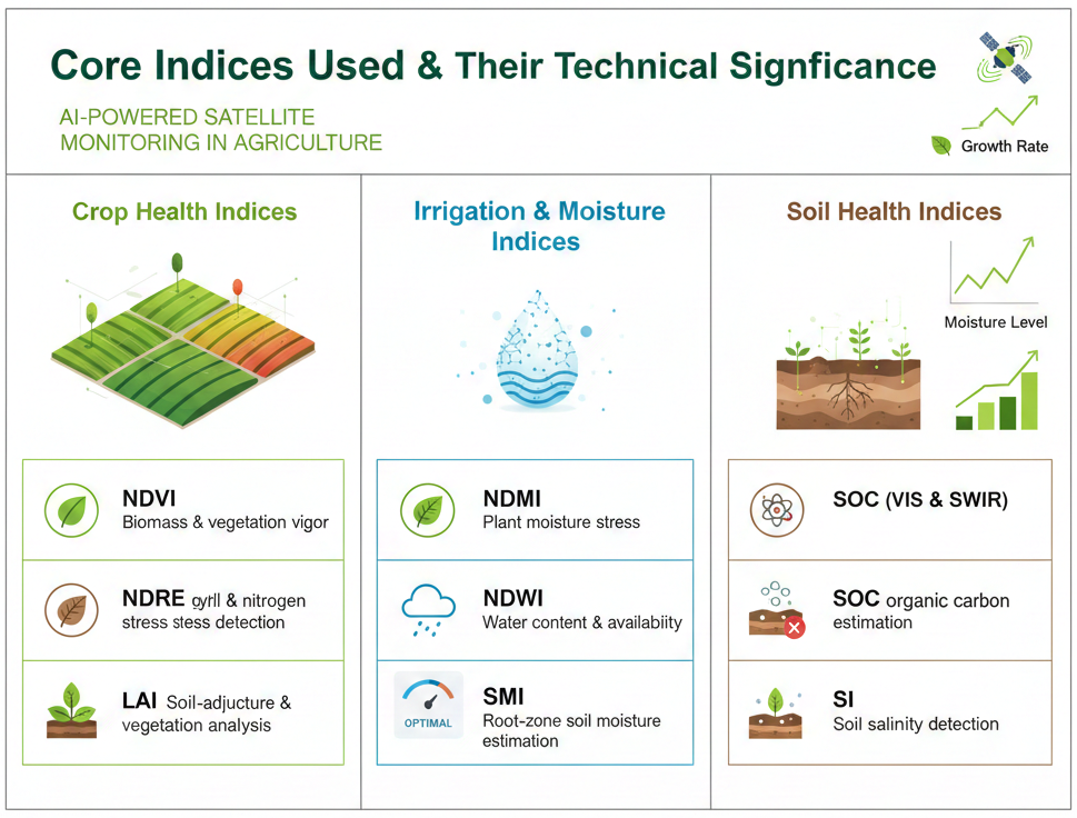
Core Indices Used & Their Technical Significance
🌱 Crop Health & Canopy Analysis
NDVI (Normalized Difference Vegetation Index)
- Formula: (NIR — Red) / (NIR + Red)
- Measures photosynthetic activity and biomass
- Detects early-stage crop decline before yield loss
EVI (Enhanced Vegetation Index)
- Corrects atmospheric noise and soil background effects
- More sensitive in dense vegetation compared to NDVI
- Ideal for tracking crop growth stages and vigor trends
NDRE (Normalized Difference Red Edge Index)
- Uses red-edge wavelength for chlorophyll estimation
- Detects nitrogen stress earlier than NDVI
- Critical for fertilizer optimization decisions
LAI (Leaf Area Index)
- Indicates leaf density and canopy structure
- Strongly correlated with crop growth rate and yield potential
SAVI (Soil Adjusted Vegetation Index)
- Adjusts vegetation signal in sparse crop or early-stage fields
- Prevents soil reflectance from skewing crop health readings
💧 Irrigation & Moisture Intelligence
NDMI (Normalized Difference Moisture Index)
- Estimates water content in vegetation tissues
- Early indicator of drought or water stress
NDWI (Normalized Difference Water Index)
- Detects surface and leaf water presence
- Helps differentiate irrigation sufficiency vs stress
SMI (Soil Moisture Index)
- Models moisture availability in the root zone
- Supports irrigation scheduling and water-use efficiency
📌 These indices together enable preventive irrigation management, not reactive watering.
🌾 Soil Health & Carbon Estimation
SOC_VIS & SOC_SWIR (Soil Organic Carbon)
- Estimated using visible and shortwave infrared reflectance
- Indicates long-term soil fertility and structure
- Helps assess soil regeneration and sustainability
Salinity Index (SI)
- Detects salt accumulation zones
- Critical for yield protection in irrigated regions
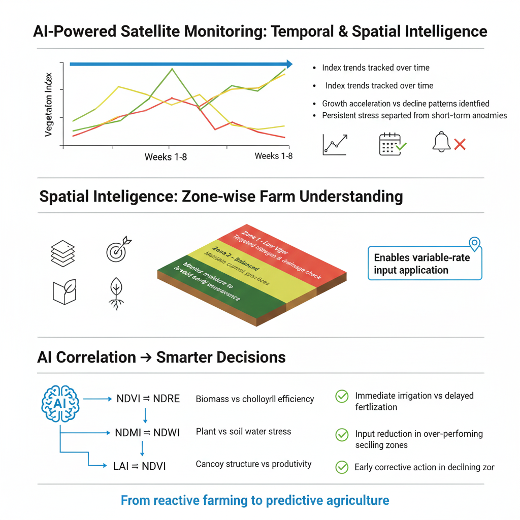
Temporal & Spatial Intelligence: Beyond a Single Image
Fasalam reports do not rely on one snapshot.
📈 Temporal Analysis
- Index trends tracked across weeks
- Growth acceleration or decline patterns identified
- Stress persistence vs short-term anomalies differentiated
🗺️ Spatial Zonation
- Fields divided into management zones
- Each zone evaluated independently
- Enables variable-rate input application
Example:
- Zone 1: Low vigor → targeted nitrogen & drainage check
- Zone 2: Balanced → maintain current practices
- Zone 3: High vigor → monitor moisture to prevent early senescence
AI-Based Correlation & Decision Logic
Beyond raw indices, our system applies correlation analysis to understand cause–effect relationships:
- NDVI vs NDRE → Biomass vs chlorophyll efficiency
- NDMI vs NDWI → Plant vs soil water stress
- LAI vs NDVI → Canopy structure vs productivity
This enables decision prioritization, such as:
- Immediate irrigation vs delayed fertilization
- Input reduction in over-performing zones
- Early corrective action in declining zones
Weather Intelligence Integration
Each report integrates:
- Real-time weather conditions
- 5–7 day forecast
- Rain probability and cloud cover
- Temperature & wind stress indicators
This ensures recommendations are weather-context aware, preventing:
- Fertilizer loss before rainfall
- Over-irrigation during cool periods
- Stress escalation during heat spells
From Data to Decisions: What Farmers Actually Gain
A single weekly report enables farmers to:
- Reduce unnecessary irrigation cycles
- Optimize fertilizer timing and dosage
- Detect stress before visible crop damage
- Improve water and nutrient use efficiency
- Make confident, evidence-backed decisions
📌 Result: Lower cost per acre + higher yield stability
The Missing Link in Agri-Tech: Human Interpretation
That’s why Fasalam follows a Human-in-the-Loop Model:
- AI-generated satellite report
- Delivery via App & WhatsApp
- Post-report discussion with farmer
- Explanation of:
- What changed this week
- What needs immediate action
- What can be safely ignored
5. Practical, crop-stage-specific guidance
This bridges the gap between remote sensing science and on-ground farming reality.
Why This Matters for Indian Agriculture
Satellite intelligence enables:
- Precision farming at smallholder scale
- Sustainable input usage
- Climate-resilient decision-making
- Scalable advisory without physical dependency
It converts farming from reactive management to predictive agriculture.

Rashail Agro’s Commitment
At Rashail Agro, we are building:
- An AI-driven agri intelligence layer
- Integrated with Fasalam Super App
- Designed for Indian field conditions
- Backed by real agronomy, not dashboards alone
“Technology should simplify farming, not complicate it.”
Looking Ahead
Satellite monitoring combined with:
- IoT sensors
- Smart irrigation controllers
- Soil diagnostics
- Market intelligence
Will create a closed-loop digital farming ecosystem — and Fasalam is building that foundation today.
🌱 Powered by Fasalam Super App | 🚜 Built by Rashail Agro | 📡 Where Satellite Intelligence Meets Soil Reality